
Pilgrim’s CompassCURATED JOURNEYS. A MORE MEANINGFUL WORLD.
← All journeys

SPAIN · PERSONALLY GUIDED

Camino de Santiago

Walk a thousand years of stories.

14 daysTIME TO EXPLORE4–8 guestsAN INTIMATE GROUPPlan this journey ↗

THE EXPERIENCE

A journey beyond
the expected.

Ancient paths. Cathedral cities. A journey with meaning. Experience the length of the Camino Francés through selected walks and private transfers, before walking the final stages from Sarria to Santiago.

FOLLOW THE JOURNEY

Your route, unfolding.

Explore the key stops along the way.
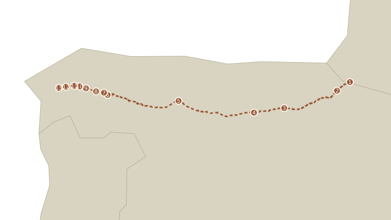
Numbered route overview linking Roncesvalles, Pamplona, Santo Domingo, Burgos, León, Samos, Portomarín, Palas de Rei, Melide, Arzúa, O Pedrouzo, Santiago
✥ SpainROUTE OVERVIEW

Camino Francés hiking trail via Samos, based on OpenStreetMap. Dashed line: full trail; numbered points: tour stops. Your tour combines selected walks and private transfers. Hiking distances and running subtotals below come from our original tour itinerary. Where elevation profiles are shown, approximate walking distances follow those supplied profiles. They count scheduled walks only, not the full trail or shuttle travel. The 10.2 km Triacastela–Samos walk is included; additional local hikes in Samos are excluded.

  1. Roncesvalles
  2. Pamplona
  3. Santo Domingo
  4. Burgos
  5. León
  6. Samos
  7. Portomarín
  8. Palas de Rei
  9. Melide
  10. Arzúa
  11. O Pedrouzo
  12. Santiago
01Roncesvalles
Arrival in Roncesvalles — no hike listedHiking total so far: 0.0 km

Begin with your Camino passport and the history of pilgrimage. Stay at Hotel Roncesvalles.

02Pamplona
Roncesvalles to Basque Irati in Espinal: 6.5 kmHiking total so far: 6.5 km

Walk 6.5 km from Roncesvalles to Espinal, then explore Pamplona’s cathedral, cafés, and pintxos.

CAMINO FRANCÉS · WALKING PROFILE

Roncesvalles to Espinal

Distance
6.5 km
Start
950 m
Finish
870 m
Roncesvalles to Espinal elevation profile Approximate 6.5 kilometre walk. Roncesvalles: 0.0 km, 950 metres; Shaded woods descent: 1.2 km, 915 metres; Burguete plain: 2.6 km, 895 metres; Burguete: 3.2 km, 890 metres; Stream crossing: 4.5 km, 880 metres; Hill climb: 5.4 km, 915 metres; Espinal: 6.5 km, 870 metres. ELEVATION · METRES 860880900920940960980 0.00.51.01.52.02.53.03.54.04.55.05.56.06.5 Roncesvalles: 0.0 km, 950 m1Shaded woods descent: 1.2 km, 915 m2Burguete plain: 2.6 km, 895 m3Burguete: 3.2 km, 890 m4Stream crossing: 4.5 km, 880 m5Hill climb: 5.4 km, 915 m6Espinal: 6.5 km, 870 m7 DISTANCE FROM RONCESVALLES · KM

Scroll the chart sideways to see the full route.

  1. Roncesvalles0.0 km · 950 m
  2. Shaded woods descent1.2 km · 915 m
  3. Burguete plain2.6 km · 895 m
  4. Burguete3.2 km · 890 m
  5. Stream crossing4.5 km · 880 m
  6. Hill climb5.4 km · 915 m
  7. Espinal6.5 km · 870 m

Approximate elevations and landmark distances, based on the supplied route profile. The line connects reference points; small terrain changes are not shown. This walk ends in Espinal, before the transfer to Pamplona.

03Santo Domingo
Two scheduled walks: 8.5 kmHiking total so far: 15.0 kmZariquiegui to Alto del Perdón: 2.4 km; Cirueña to Santo Domingo de la Calzada: 6.1 km.

Walk from Zariquiegui to Alto del Perdón (2.4 km), then from Cirueña to Santo Domingo de la Calzada (6.1 km), then explore the cathedral and learn of the miracles of St. James.

CAMINO FRANCÉS · WALKING PROFILE

Zariquiegui to Alto del Perdón

Distance
2.4 km
Start
560 m
Finish
770 m
Zariquiegui to Alto del Perdón elevation profile Approximate 2.4 kilometre walk. Zariquiegui: 0.0 km, 560 metres; Farming tracks curve: 0.6 km, 595 metres; Base of mountain path: 1.2 km, 640 metres; Rocky switchbacks: 1.8 km, 700 metres; Alto del Perdón: 2.4 km, 770 metres. ELEVATION · METRES 560600640680720760800 0.00.20.40.60.81.01.21.41.61.82.02.22.4 Zariquiegui: 0.0 km, 560 m1Farming tracks curve: 0.6 km, 595 m2Base of mountain path: 1.2 km, 640 m3Rocky switchbacks: 1.8 km, 700 m4Alto del Perdón: 2.4 km, 770 m5 DISTANCE FROM ZARIQUIEGUI · KM

Scroll the chart sideways to see the full route.

  1. Zariquiegui0.0 km · 560 m
  2. Farming tracks curve0.6 km · 595 m
  3. Base of mountain path1.2 km · 640 m
  4. Rocky switchbacks1.8 km · 700 m
  5. Alto del Perdón2.4 km · 770 m

Approximate elevations and landmark distances, based on the supplied route profile. The line connects reference points; small terrain changes are not shown. This 2.4 km walk climbs from Zariquiegui to Alto del Perdón.

CAMINO FRANCÉS · WALKING PROFILE

Cirueña to Santo Domingo de la Calzada

Distance
6.1 km
Start
741 m
Finish
646 m
Cirueña to Santo Domingo de la Calzada elevation profile Approximate 6.1 kilometre walk. Cirueña center: 0.0 km, 741 metres; Resort outskirts: 1.5 km, 725 metres; Agricultural tracks: 3.5 km, 680 metres; Urban perimeter: 5.0 km, 652 metres; Santo Domingo historic center: 6.1 km, 646 metres. ELEVATION · METRES 630650670690710730750770 0.00.51.01.52.02.53.03.54.04.55.05.56.1 Cirueña center: 0.0 km, 741 m1Resort outskirts: 1.5 km, 725 m2Agricultural tracks: 3.5 km, 680 m3Urban perimeter: 5.0 km, 652 m4Santo Domingo historic center: 6.1 km, 646 m5 DISTANCE FROM CIRUEÑA · KM

Scroll the chart sideways to see the full route.

  1. Cirueña center0.0 km · 741 m
  2. Resort outskirts1.5 km · 725 m
  3. Agricultural tracks3.5 km · 680 m
  4. Urban perimeter5.0 km · 652 m
  5. Santo Domingo historic center6.1 km · 646 m

Approximate elevations and landmark distances, based on the supplied route profile. The line connects reference points; small terrain changes are not shown. This 6.1 km walk descends from Cirueña to the historic center of Santo Domingo de la Calzada.

04Burgos
Burgos — sightseeing; no hike listedHiking total so far: 15.0 km

Discover the cathedral, the castle, and the story of El Cid.

05León
León — sightseeing; no hike listedHiking total so far: 15.0 km

Admire the stunning stained glass of León’s cathedral, explore the Basilica de San Isidoro, see Urraca’s holy grail, and admire one of the few architectural wonders of Gaudí at the Casa Botines.

06Samos
Triacastela to Samos: 10.2 kmListed hiking subtotal: 25.2 kmTriacastela to Samos: 10.2 km. Additional local hikes are not included. Subtotal excludes any additional local hikes in Samos.

Walk from Triacastela to Samos (10.2 km) and discover the secrets of a fifth-century monastery.

CAMINO FRANCÉS · WALKING PROFILE

Triacastela to Samos

Distance
10.0 km
Start
664 m
Finish
529 m
Triacastela to Samos elevation profile Approximate 10.0 kilometre walk. Triacastela: 0.0 km, 664 metres; San Cristovo do Real: 3.9 km, 589 metres; Renche: 5.7 km, 594 metres; Lastres: 6.1 km, 582 metres; Freituxe: 7.3 km, 581 metres; San Martiño do Real: 8.5 km, 562 metres; Samos: 10.0 km, 529 metres. ELEVATION · METRES 500550600650700 0.02.04.06.08.010.0 Triacastela: 0.0 km, 664 m1San Cristovo do Real: 3.9 km, 589 m2Renche: 5.7 km, 594 m3Lastres: 6.1 km, 582 m4Freituxe: 7.3 km, 581 m5San Martiño do Real: 8.5 km, 562 m6Samos: 10.0 km, 529 m7 DISTANCE FROM TRIACASTELA · KM

Scroll the chart sideways to see the full route.

  1. Triacastela0.0 km · 664 m
  2. San Cristovo do Real3.9 km · 589 m
  3. Renche5.7 km · 594 m
  4. Lastres6.1 km · 582 m
  5. Freituxe7.3 km · 581 m
  6. San Martiño do Real8.5 km · 562 m
  7. Samos10.0 km · 529 m

Approximate landmark elevations and distances from Senditur’s Triacastela–Sarria via Samos route guide, using only the section ending in Samos. The smooth line connects reference points; small terrain changes are not shown. The source measures approximately 10.0 km to Samos; our scheduled walk is 10.2 km, as listed in our itinerary.

07Portomarín
Sarria to Portomarín: 22.2 kmListed hiking subtotal: 47.4 kmSubtotal excludes any additional local hikes in Samos.

Walk 22.2 km from Sarria to Portomarín where you can visit the unique temple fortress of the Knights Hospitallers, the Igrexa de San Xoán.

CAMINO FRANCÉS · WALKING PROFILE

Sarria to Portomarín

Distance
22.2 km
Start
440 m
Finish
350 m
Sarria to Portomarín elevation profile Approximate 22.2 kilometre walk. Sarria: 0.0 km, 440 metres; Barbadelo: 3.6 km, 580 metres; Rolling countryside: 7.3 km, 560 metres; Morgade Ridge: 12.0 km, 665 metres; Ferreiros: 13.5 km, 620 metres; Descent toward Portomarín: 17.0 km, 550 metres; Final descent: 20.0 km, 480 metres; Portomarín: 22.2 km, 350 metres. ELEVATION · METRES 300400500600700 0.04.08.012.016.020.022.2 Sarria: 0.0 km, 440 m1Barbadelo: 3.6 km, 580 m2Rolling countryside: 7.3 km, 560 m3Morgade Ridge: 12.0 km, 665 m4Ferreiros: 13.5 km, 620 m5Descent toward Portomarín: 17.0 km, 550 m6Final descent: 20.0 km, 480 m7Portomarín: 22.2 km, 350 m8 DISTANCE FROM SARRIA · KM

Scroll the chart sideways to see the full route.

  1. Sarria0.0 km · 440 m
  2. Barbadelo3.6 km · 580 m
  3. Rolling countryside7.3 km · 560 m
  4. Morgade Ridge12.0 km · 665 m
  5. Ferreiros13.5 km · 620 m
  6. Descent toward Portomarín17.0 km · 550 m
  7. Final descent20.0 km · 480 m
  8. Portomarín22.2 km · 350 m

Approximate elevations and landmark distances, based on the supplied route profile. The line connects reference points; small terrain changes are not shown. Climb to Morgade Ridge before descending to Portomarín.

08Palas de Rei
Portomarín to Palas de Rei: 24.8 kmListed hiking subtotal: 72.2 kmSubtotal excludes any additional local hikes in Samos.

Walk 24.8 km from Portomarín to Palas de Rei.

CAMINO FRANCÉS · WALKING PROFILE

Portomarín to Palas de Rei

Distance
24.8 km
Start
346 m
Finish
565 m
Portomarín to Palas de Rei elevation profile Approximate 24.8 kilometre walk. Portomarín: 0.0 km, 346 metres; Gonzar: 7.9 km, 540 metres; Climb beyond Gonzar: 9.5 km, 600 metres; Approach to the ridge: 11.5 km, 650 metres; Sierra de Ligonde: 13.0 km, 725 metres; Descent from the ridge: 16.2 km, 590 metres; Low point before Palas de Rei: 19.7 km, 540 metres; Palas de Rei: 24.8 km, 565 metres. ELEVATION · METRES 300400500600700800 0.04.08.012.016.020.024.8 Portomarín: 0.0 km, 346 m1Gonzar: 7.9 km, 540 m2Climb beyond Gonzar: 9.5 km, 600 m3Approach to the ridge: 11.5 km, 650 m4Sierra de Ligonde: 13.0 km, 725 m5Descent from the ridge: 16.2 km, 590 m6Low point before Palas de Rei: 19.7 km, 540 m7Palas de Rei: 24.8 km, 565 m8 DISTANCE FROM PORTOMARÍN · KM

Scroll the chart sideways to see the full route.

  1. Portomarín0.0 km · 346 m
  2. Gonzar7.9 km · 540 m
  3. Climb beyond Gonzar9.5 km · 600 m
  4. Approach to the ridge11.5 km · 650 m
  5. Sierra de Ligonde13.0 km · 725 m
  6. Descent from the ridge16.2 km · 590 m
  7. Low point before Palas de Rei19.7 km · 540 m
  8. Palas de Rei24.8 km · 565 m

Approximate elevations and landmark distances, based on the supplied route profile. The line connects reference points; small terrain changes are not shown. The highest reference point is Sierra de Ligonde at 725 m.

09Melide
Palas de Rei to Melide: 15.0 kmListed hiking subtotal: 87.2 kmSubtotal excludes any additional local hikes in Samos.

Walk 15.0 km from Palas de Rei to Melide.

CAMINO FRANCÉS · WALKING PROFILE

Palas de Rei to Melide

Distance
15.0 km
Start
565 m
Finish
420 m
Palas de Rei to Melide elevation profile Approximate 15.0 kilometre walk. Palas de Rei: 0.0 km, 565 metres; San Xulián do Camiño: 3.4 km, 460 metres; Ponte Campaña: 5.7 km, 430 metres; Mato Casanova Ridge: 8.5 km, 520 metres; Furelos River Bridge: 11.5 km, 380 metres; Melide outskirts: 13.5 km, 415 metres; Melide town center: 15.0 km, 420 metres. ELEVATION · METRES 350400450500550600 0.03.06.09.012.015.0 Palas de Rei: 0.0 km, 565 m1San Xulián do Camiño: 3.4 km, 460 m2Ponte Campaña: 5.7 km, 430 m3Mato Casanova Ridge: 8.5 km, 520 m4Furelos River Bridge: 11.5 km, 380 m5Melide outskirts: 13.5 km, 415 m6Melide town center: 15.0 km, 420 m7 DISTANCE FROM PALAS DE REI · KM

Scroll the chart sideways to see the full route.

  1. Palas de Rei0.0 km · 565 m
  2. San Xulián do Camiño3.4 km · 460 m
  3. Ponte Campaña5.7 km · 430 m
  4. Mato Casanova Ridge8.5 km · 520 m
  5. Furelos River Bridge11.5 km · 380 m
  6. Melide outskirts13.5 km · 415 m
  7. Melide town center15.0 km · 420 m

Approximate elevations and landmark distances, based on the supplied route profile. The line connects reference points; small terrain changes are not shown. Descend to the Furelos River before the final climb into Melide.

10Arzúa
Melide to Arzúa: 13.8 kmListed hiking subtotal: 101.0 kmSubtotal excludes any additional local hikes in Samos.

Walk 13.8 km from Melide to Arzúa.

CAMINO FRANCÉS · WALKING PROFILE

Melide to Arzúa

Distance
13.8 km
Start
420 m
Finish
390 m
Melide to Arzúa elevation profile Approximate 13.8 kilometre walk. Melide center: 0.0 km, 420 metres; Raído Valley Basin: 2.0 km, 395 metres; Parabispa: 4.0 km, 380 metres; Boente Valley Floor: 6.0 km, 330 metres; Boente de Arriba: 7.0 km, 375 metres; Castañeda Ridge: 8.5 km, 390 metres; Ribadiso River Valley: 10.0 km, 290 metres; As Barrosas: 12.0 km, 350 metres; Arzúa town center: 13.8 km, 390 metres. ELEVATION · METRES 250300350400450 0.02.04.06.08.010.012.013.8 Melide center: 0.0 km, 420 m1Raído Valley Basin: 2.0 km, 395 m2Parabispa: 4.0 km, 380 m3Boente Valley Floor: 6.0 km, 330 m4Boente de Arriba: 7.0 km, 375 m5Castañeda Ridge: 8.5 km, 390 m6Ribadiso River Valley: 10.0 km, 290 m7As Barrosas: 12.0 km, 350 m8Arzúa town center: 13.8 km, 390 m9 DISTANCE FROM MELIDE · KM

Scroll the chart sideways to see the full route.

  1. Melide center0.0 km · 420 m
  2. Raído Valley Basin2.0 km · 395 m
  3. Parabispa4.0 km · 380 m
  4. Boente Valley Floor6.0 km · 330 m
  5. Boente de Arriba7.0 km · 375 m
  6. Castañeda Ridge8.5 km · 390 m
  7. Ribadiso River Valley10.0 km · 290 m
  8. As Barrosas12.0 km · 350 m
  9. Arzúa town center13.8 km · 390 m

Approximate elevations and landmark distances, based on the supplied route profile. The line connects reference points; small terrain changes are not shown. Cross the Boente and Ribadiso valleys before climbing into Arzúa.

11O Pedrouzo
Arzúa to O Pedrouzo: 19.3 kmListed hiking subtotal: 120.3 kmSubtotal excludes any additional local hikes in Samos.

Walk 19.3 km from Arzúa to O Pedrouzo.

CAMINO FRANCÉS · WALKING PROFILE

Arzúa to O Pedrouzo

Distance
19.3 km
Start
390 m
Finish
280 m
Arzúa to O Pedrouzo elevation profile Approximate 19.3 kilometre walk. Arzúa: 0.0 km, 390 metres; A Calzada: 5.0 km, 380 metres; Rolling countryside: 8.5 km, 375 metres; Low point before Santa Irene: 11.5 km, 360 metres; Approach to Santa Irene: 15.0 km, 390 metres; Santa Irene: 16.5 km, 410 metres; Valley before O Pedrouzo: 18.0 km, 260 metres; O Pedrouzo: 19.3 km, 280 metres. ELEVATION · METRES 200250300350400450 0.03.06.09.012.015.019.3 Arzúa: 0.0 km, 390 m1A Calzada: 5.0 km, 380 m2Rolling countryside: 8.5 km, 375 m3Low point before Santa Irene: 11.5 km, 360 m4Approach to Santa Irene: 15.0 km, 390 m5Santa Irene: 16.5 km, 410 m6Valley before O Pedrouzo: 18.0 km, 260 m7O Pedrouzo: 19.3 km, 280 m8 DISTANCE FROM ARZÚA · KM

Scroll the chart sideways to see the full route.

  1. Arzúa0.0 km · 390 m
  2. A Calzada5.0 km · 380 m
  3. Rolling countryside8.5 km · 375 m
  4. Low point before Santa Irene11.5 km · 360 m
  5. Approach to Santa Irene15.0 km · 390 m
  6. Santa Irene16.5 km · 410 m
  7. Valley before O Pedrouzo18.0 km · 260 m
  8. O Pedrouzo19.3 km · 280 m

Approximate elevations and landmark distances, based on the supplied route profile. The line connects reference points; small terrain changes are not shown. Gentle rolling terrain leads to Santa Irene, followed by a descent and a short climb into O Pedrouzo.

12Santiago
O Pedrouzo to Santiago de Compostela: 19.4 kmListed hiking subtotal: 139.7 kmSubtotal excludes any additional local hikes in Samos.

Walk the final 19.4 km to Santiago de Compostela and its extraordinary cathedral.

CAMINO FRANCÉS · WALKING PROFILE

O Pedrouzo to Santiago de Compostela

Distance
19.4 km
Start
280 m
Finish
260 m
O Pedrouzo to Santiago de Compostela elevation profile Approximate 19.4 kilometre walk. O Pedrouzo: 0.0 km, 280 metres; Valley before Cimadevilla: 3.5 km, 250 metres; Cimadevilla High Point: 6.3 km, 387 metres; A Lavacolla: 10.0 km, 290 metres; Monte do Gozo: 15.0 km, 370 metres; Santiago Cathedral: 19.4 km, 260 metres. ELEVATION · METRES 200250300350400450 0.03.06.09.012.015.018.019.4 O Pedrouzo: 0.0 km, 280 m1Valley before Cimadevilla: 3.5 km, 250 m2Cimadevilla High Point: 6.3 km, 387 m3A Lavacolla: 10.0 km, 290 m4Monte do Gozo: 15.0 km, 370 m5Santiago Cathedral: 19.4 km, 260 m6 DISTANCE FROM O PEDROUZO · KM

Scroll the chart sideways to see the full route.

  1. O Pedrouzo0.0 km · 280 m
  2. Valley before Cimadevilla3.5 km · 250 m
  3. Cimadevilla High Point6.3 km · 387 m
  4. A Lavacolla10.0 km · 290 m
  5. Monte do Gozo15.0 km · 370 m
  6. Santiago Cathedral19.4 km · 260 m

Approximate elevations and landmark distances, based on the supplied route profile. The line connects reference points; small terrain changes are not shown. The final stage crosses Monte do Gozo before descending to Santiago Cathedral.

THOUGHTFULLY TAKEN CARE OF

More presence.
Fewer logistics.

  • ✓   Private shuttle and luggage transfers
  • ✓   Distinctive hotels and Paradores
  • ✓   Breakfast and dinner at each location
  • ✓   Personal guidance in history, theology, and literature
  • ✓   Pilgrim’s Compass daypack, travel guide, and journal

Dates, availability, accommodation details, and the final itinerary are confirmed personally before booking.

YOUR NEXT CHAPTER

Every great journey
starts with a conversation.

Tell Keri and Ryan where you’d like to go. We’ll help you find the right journey—or shape one around you.

Opens an email draft to Keri and Ryan. Nothing is sent automatically.

KEEP EXPLORING

A different direction?